Galooli solution offers the user to view selected points of interest (POI) or to structure a virtual parameter within a specified geographical area (Geofence). Both POI and Geofence will appear in the map display and the user can request events that indicate the presence of the unit in or outside the desired Geofence.
...
Alternates between showing the POI and Labels or hiding them
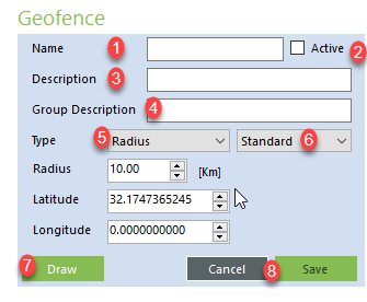
Adding Geofence
Name of the geofence as it will appear in the left navigation and on the map display
...
When using the Draw function, center the map on the desired location and use the mouse cursor to perform the drawing.
Editing Geofence
...
Users can choose from the following options:
...
Remove Geofence - Completely removes the geofence
Geofencing Events
Geofencing events are based on the unit's location as detected in the GPS. Users may receive event notifications in case the unit leaves the geofence and in case the unit enters the geofence. Events should be added in the Events tab under Location Events and are considered Advisory priority.
...
Polygon Geofence Creation
When a user wants to set any polygon geofence within his organization, it is important that during the drawing process, you will have to double click on any of the blue dots to save the polygon configuration.
...
Once you double-click the dots, they will disappear, and you will be able to save the geofence using the “save”.
...

